Day 1 – Donaldsonville to Napoleonville – 4/9/14
This is my second attempt at paddling the 106-mile Bayou Lafourche from source to mouth. My first attempt, back in July of 2010, ended at mile 75 in heat stroke and exhaustion. That would not happen again, and I made sure of it by taking specific precautions. In 2010 I planned for six days of paddling, but on this trip I would allow for eight days. This made for shorter paddles and more time for breaks each day. Secondly, a week before starting the trip, I drove the length of the bayou and knocked on a few doors, pitching my trip in hopes of lining up a few more places to camp. I found nice folks in Napoleonville and Raceland that didn’t mind a stranger camping on their bayou-side property. Most importantly, I paddled in April as opposed to late July – the dead of summer. On average in south Louisiana, April weather is typically twenty degrees cooler and half as rainy – perfect!


On the first day, Angela dropped me off on a long sloping bank in Donaldsonville. It would be a late start, but that didn’t matter. With only 14.5 miles to paddle on the day, I had plenty of time for dilly-dallying. Angela helps me unpack the car and strategically repack the boat’s hatches with several days worth of food and gear. The slope is not very far from the source where a relatively new pumping structure diverts Mississippi River water into Bayou Lafourche at up to 1,000 cubic feet per second. I can feel the current here in Donaldsonville, yet I know that this helpful push will not last the length of the bayou. I take advantage of the current and drift away from the bank, steering more than paddling at first. As I wind through Donaldsonville, my boat is escorted by Black-bellied Whistling ducks later followed by Mallards. Passing through Belle Rose, the duck population dwindled but was supplemented by Great Egrets and lots of turtles.

I make my way past uncountable logs that look like alligators, and I know that at some point on this trip, one of these logs will be an alligator. This one annoying sticky thought won’t leave me, and I am basically left with a fear of logs. I deal with it and paddle on.


On the north end of Paincourtville, I pull up onto a steep bank by a bridge where a fisherman named Jerald helped me out of my boat. I stretched my legs as Jerald cast his line into the middle of the bayou. Something immediately tugged at his line and he reeled in to reveal his catch – an eel! I thought he would throw it back into the water, but he kept the creature. We got to talking -Jerald mostly. He told me about how he likes to come out every day and fish for bass.
“I like to fish because it gets me out of the house,” he said. “Otherwise, I’m sitting inside all day. It passes the time.”
Jerald also mentioned that he’s noticed an increasingly strong flow of water in the bayou over the years. Of course he’s right about that. The Bayou Lafourche Fresh Water District aims to divert 1,000 cubic feet of water per second from the Mississippi into Bayou Lafourche. Several stages of the plan are already completed: new pumps at the headwaters and dredging of the bayou. Other steps are yet to be completed like replacing the Union Pacific Railroad Bridge, creating new control structures, and removing the weir in Thibodeaux.
I mentioned toJerald that I was working up an appetite. He recommended that I check out the Shell gas station in Paincourtville. “They have a little kitchen and make some real good seafood dishes there.” That’s all I needed to know.
Just as I was shoving off again Jerald called out, “Have you seen any gators yet?”
“No”, I replied. “You see any?”
“Oh yea. They’re all over the bayou. Be careful, I saw a big one right here just yesterday.”
The gator report did not help my newfound irrational fear of logs. A little further down the bayou, rushing past one thing or another, I must have missed the Shell station. Lunch would have to come from another source. Right as I realized that I had missed my stop, a large gator launched itself off the bank and swam right under my boat – at least half the size of the kayak so about eight feet. “They’re more afraid of you than you are of them,” was the lie that I repeated over and over to myself until I felt safe again.


I arrived at Napoleonville at about 4pm only to realize that the bank on where I was supposed to land was too steep. I ended up docking on the opposite bank, attaching the wheel kit, and carrying my rig across a nearby bridge. I’m lucky that was even an option. Had that bridge not been there, I would have been forced to leave my boat in the water and scramble up the bayou-side with all my gear.
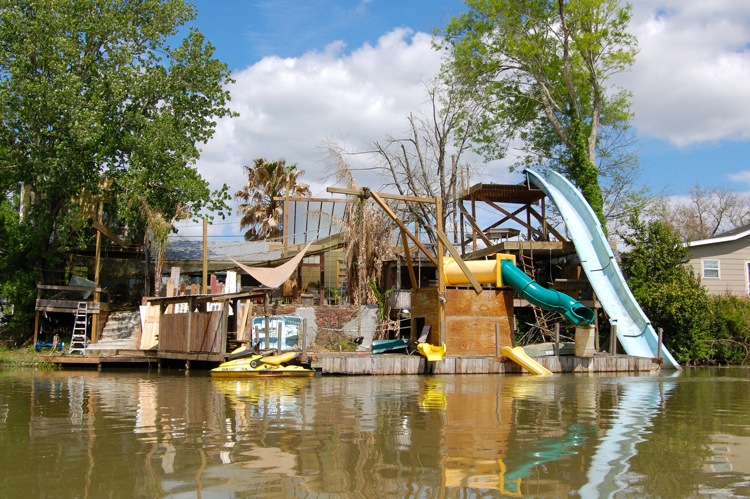
My stopover in Napoleonville was a product of those door to door visits from the week prior. In those kayaking cold calls, I was fortunate to knock on the door of Regina Smith. She and her family were inviting and friendly. When I arrived, Regina and her daughter were washing their car in the driveway. Regina’s husband was still at work. They took me in and showed me the area behind the driveway reserved for my tent. I began to unpack. Upon digging into my boat for the first time that day, I realized that the back hatch was flooded! Crackers, sleeping bag, tent, and hoodie were completely drenched. I figured out later that the flooding probably happened while pulling my boat up a steep bank. The steep incline sent water rushing to the back of the boat where my ancient, poorly caulked bulkheads, allowed water to pass right through. I spent at least an hour wringing out and hanging up items to dry. Then, starving and craving calories of any kind, I caught wind of a burger joint two miles down the road. I walked the two miles to the Dairy Inn in Napoleonville, where I treated myself to a giant burger, french fries, and a beer.


Back at Regina’s place, the sun was still up, but I was exhausted . Sunshine or not, it was time for bed. Just as I was drifting off, the sounds of live acoustic guitar crept into my tent followed by singing. There was a concert happening in the backyard! I had to check it out, so I crawled out of my tent and took a peek. Regina’s son and daughter had kicked off a jam session on the back patio, and they were talented. Turns out, the daughter had been part of a team that won a national country music contest. She had a great voice, and the brother played a pretty good guitar. It was an amusing end to the day – being serenaded by siblings on Bayou Lafourche playing Oasis, “In a champagne supernova in the sky…”

Day 2 – Napoleonville to Thibodeaux – 4/10/14
I awoke hungry the next morning and needed some quick sustenance before paddling off. The Pop-n-Go convenient store across the bayou had mediocre biscuits and coffee, but they were calories nonetheless. “Breakfast” was followed by a stroll around town as I photographed the ramshackle, crumbling buildings of Napoleonville. After the photography stroll, I packed up the kayak, attached the wheel kit, and pulled everything back across the bridge where I shoved off for Thibodeaux.


I knocked out a bunch of miles right away, mostly due to the fact that I couldn’t find a place to stop. I just kept going, almost nine miles straight, until finally finding a great spot to get out of the boat – under the bridge in Labadieville. There, I took out all my electronics and threw them in a backpack, secured the rest of my stuff under the bridge, and climbed up and over into town where I quickly found Amy and Emily’s Cajun Cafe. There, I had a superb dinner of crab and shrimp gumbo with onion rings – one of the best meals I’ve ever had on a trip like this.


Reenergized, I paddled on and arrived in Thibodeaux ahead of schedule. The bank alongside David and Sharon Gauthe’s house was steeper that I’d remembered from my previous trip down the bayou. The water level in the bayou was so low, that I had no choice but to commit to a wet exit. I threw my paddle up on the bank, rolled up my pants, and hopped out into the water.
I first met the Gauthe family back in the mid 90s. Their daughter Miki and I attended different high schools, but we were both very active in our respective school band programs. Our paths crossed at many of the same Lafourche Parish band festivals, contests, and honor bands. Miki and I quickly became friends, our friends circles meshed, and I eventually met her family. Everyone should have the pleasure to know a family like the Gauthes. Miki was always as kind as a person can be. Always smiling and laughing, she could lift anyone’s spirits. Her parents David and Sharon are exactly the same way: bubbly, warm, generous, and absolute salt of the earth through and through.
This stop at the Gauthe’s was scheduled, but I had not expected to see anyone at the house. They were supposed to be out of town. I figured that I would just drag my gear up to the house, camp out for the night, and take off in the morning. To my pleasant surprise, David and Sharon had not yet left for their trip – they were running a little late. I rolled over to the house and Mrs. Sharon popped out of the front door. I smelled like a stagnant bayou, but she invited me in without batting an eye. Mr. David joined us as we caught up. I rolled my rig behind their house, set up my tent in their giant back yard, and started to hang up clothes and gear to dry. Mr. David came out and we talked for quite a while. He showed me how he repurposed a trampoline into a greenhouse for his vegetables and how the playhouse was actually set up on giant sleds so that he could pull it around with his tractor! A diagonal path cut straight through a massive patch of clovers – a clearing for all the children who would participate in the upcoming easter egg hunt. He told me about how he used to work at an old sugar mill, and he took me into his shed to show me the huge collection of ancient, pre-electricity, sugar mill tools. When we came out the shed, we were greeted by Mrs. Sharon. Very ready to hit the road, it was obvious that she had been looking for us. My tour of the shed was over.


Day 3 – Thibodeaux to Raceland – 4/11/14
In the morning everything was soaked from the dew. All of the clothes and gear that I had hung up to dry was wetter than before. I also woke up with a very upset stomach – not the kind of ailment you’d like to have when hopping into a kayak for unknown hours. My morning felt wasted, waiting for things to dry and for my stomach to settle. I took this opportunity to charge my batteries, and finally at 9:10AM I felt confident enough to start my paddle.

I stopped, after only two miles of paddling, at the Wetlands Acadian Cultural Center in Thibodeaux – one of six sites that makes up the Jean Lafitte National Historic Park and Preserve. I walked around town a little, probably just stalling for the unavoidable task ahead, getting around or over the weir in Thibodeaux.


A weir is a man-made blockage of a body of water, typically used to divert or change the flow in some way – think tiny dam. Bayou Lafourche currently has one such weir in Thibodeaux. On my last trip, I laughably pulled out of the bayou, attached the wheel kit, and lugged my 80+ pound rig through the city. By the time I got back to the bayou, I was exhausted. The steep slope back into the water was lined with jagged concrete blocks and oyster shells. I shredded both my legs and the underside of my kayak on this sawtoothed slope. My new plan was to pull out earlier, leave the boat in the water, and simply tow it over the weir. That idea fizzled as soon as I pulled up to the barrier. A fence jutting from the bank thwarted my plan (you can see it in the background of the image below). I would have to pull the boat up the bank and around again. This time, once atop the bank, I would only have to drag the boat about 200 feet before lowering it back down into the water. I got as close as I could to the weir and hopped out of my boat as carefully as I could, trying not to disturb a giant mother duck on its nest. I slowly pulled the heavy load up the steep slope, pushed it a few hundred feet along the downtown Thibodeaux sidewalk, and with a rope, slowly lowered it down the jagged concrete and oyster shell strewn slope on the other side of the weir. In 2011, it took me 1 hour and 50 minutes to navigate around the weir. On this trip I hopped around it in a mere 30 minutes.


After the weir, there was no place to stop for a while – too long actually. Thick vegetation and no trespassing signs kept me off the bank. Finally, about 4+ miles down the bayou, I spotted a very inviting concrete boat launch. There were no signs to turn me away, so I drifted in to stretch my legs and get a snack. I started to think about it. If I was going to stick around on someone else’s property, it might be a good idea to get permission to be there. On my way up the gravel walkway I noticed a stack of crab traps with a medium sized songbird trapped in one. The property had various animal traps, bails of hay, and lots of farming equipment. As I continued around the structure that I thought was a house, I came to realize that it wasn’t really a house but a large house-like building, probably serving as storage. Now, about 500 feet into the property, I saw something that made my heart sink – a large Bullmastiff. More importantly, it noticed me and it wasn’t tethered to anything! “No sudden movements,” I told myself. My head swiveled as I noticed something in the corner of my eye, a second Bullmastiff! “No sudden movements,” I repeated to myself as I backed away slowly and calmly. I blink and the two dogs simultaneously charge me. (Looking back on this incident with the dogs, I realize it was the only moment of the trip when I completely forgot about alligators.) Before I know what’s happening, both dogs are jumping up alongside me and nipping at my hands and face. I’m astounded by how high they can jump. They’re jumping, nipping, and shoving me around with their weight – I imagine 200+ pounds of dog, all muscle. I’m reminded of Will Farrell and Chris Kattan in that Saturday Night Live A Night at the Roxbury skit? I felt like one of their dance floor victims, only I might lose a finger. The tense walk back to the bayou-side seemed an eternity, but once I got to the concrete slope, the dogs stopped barking and just stared. It was like someone had flipped a switch, and that’s exactly what it was. If you look at the image of my puppy friend below, you can see the radial collar around his neck. As I paddled away, I thought about that poor songbird stuck in the crab trap. Curiosity had doomed us both, but at least I made it out of there.

I made great time between Thibodeaux and Raceland for two reasons: (1) There was yet again no place to get out of the boat for a breather, and (2) I came within paddle’s reach of a 6+ foot alligator – TOO CLOSE! It’s amazing how motivating it is to see a deadly creature in your path. As I made my way south, I passed under the old Lafourche Crossing railroad bridge. The first trolling boats I’d seen on my trip marked my crossing over into Raceland – the place where I was born.


In Raceland, I had arranged to camp in the yard of the Matherne family – more kind folks who said “yes” when a stranger knocked on their door. Upon arrival, I set up my tent and spoke with Mr. Matherne on his gorgeous bayou-side gazebo. Hungry, I inquired about food. Pickings were slim, and I decided to walk about 3 miles to the po-boy shop. On foot along HWY. 1, something overhead caught my eye. It wasn’t a vulture. Maybe it was a large hawk? I lost it behind some trees and kept walking. About a quarter mile later an eagle swoops down, scoops a fish out of Bayou Lafourche, and climbs up and away over the tree line! This blew my mind. Not only have I never seen an eagle do that, but I’ve never even seen an eagle on the bayou. It was an astonishing moment that I would not soon forget.

Not long after this spectacle, I found myself walking past a seafood processor. A fisherman, loading crab pots into truck engaged me in a conversation, “Where you going”?
“Po-boy place up the road,” I replied.
“In Raceland?”
“Yep”
He looked back at his pots, “All I can offer you is the back of the truck, but it stinks because of the crab pots. Up to you.”
“No, that’s perfect.” I was excited to cut some time off my walk. “I’ve been paddling all day, so I must smell bad anyway.”
We zipped there. Every minute of the ride smelled like rotten mud, but I couldn’t stop smiling. The drive took about 40 minutes off my walk. I ordered a catfish po-boy and a coke at the New Orleans Po-Boy Shop which used to be the old Frost Stop. The sandwich was good, and the lonely woman behind the counter was true blue. She hustled just to keep up with the after work / after school rush. I didn’t mind the long walk back to the Matherne’s place. The sun setting over my left shoulder, I thought about how hard I had worked for that catfish today. Then I thought about the eagle catching and eating his fish. Mr. Matherne and I talked some more on his beautiful gazebo overlooking the bayou. It was lined with cypress trees, and hidden amongst the brush all around was a system of pipes that emitted mosquito repellant. It was perfect. He told me about the history of his piece of land and his family. I felt very welcome there. I rested out on the gazebo until dusk and then retired to my tent.

Day 4 – Raceland to Lockport – 4/12/14
Very early the next morning, I found myself walking through the St. Mary’s cemetery. It was perfect cemetery weather – early Saturday, so the town was still asleep. Fog had rolled in overnight, and it was overcast. I read names on the headstones, wondering how many might be of relation to me. I found only 1 that shared my name – Amanda Lasseigne (formerly Naquin) was born in 1860 and died on February 4, 1938. I have been unable to find any additional record of her.


I packed up, thanked Mr. Matherne again, and started my short trip to Lockport. Just after the HWY 90 overpass about 4-5 miles down the bayou (see image below) I pulled off onto a smooth, freshly manicured grassy bank. Instantly, a man approaches me on a three-wheeler, sporting a poison spraying apparatus on his back. I am sure I’m about to get run off when he says, “Hey, you’re that guy that’s paddling all the way down to Fourchon right? You stayed at the Matherne’s last night right?” I couldn’t believe it, how did he know that? It turned out he was a cousin of Mr. Matherne and he was getting the property ready for a wedding. We chewed the fat for a moment and he went on to spray the weeds along the bayou. Small world down here.


Back in the boat again, I paddled straight through to Lockport. On the way I saw many more turtles, an 8+ foot gator (they were growing), and an uptick in troll boats.


In Lockport, I had arranged to stay with my elementary school librarian (and my mom’s good friend) Mrs. Champagne. In the heart of Lockport, Bayou Lafourche intersects with Old Company Canal, and Mrs. Champagne’s backyard overlooks this canal. As I approached the bank, her neighbor saw me coming and offered his wharf. He was super nice and a big-time fisherman – the kind of guy that pulls in his limit every time he goes out. I am the exact opposite. If you take me fishing, we will catch no fish. Odds are, we will at some point debate whether or not to eat the bait. I visited with Champagne’s neighbor for a while, and he informed me that I was visiting at a great time. Lockport was hosting a Wooden Boat Festival – what a fantastic surprise.

I cleaned up and walked over to the other side of the canal to the Center for Traditional Louisiana Boat Building. There were several examples of hand made wooden boats (old and new), old engines, live music, boat rides on the old wooden boats with the old engines, a silent auction, men making flies for fly fishing, live duck carving, and good food. Starving from the paddling, I ate for two: crawfish étouffée and a pork grillades po-boy – both delicious. After the festival, I grabbed a snowball from Steph’s Snowballs and walked around Lockport for a change of scenery. I made my way back to Mrs. Champagne’s and set up for the night. That evening, serenaded by frogs and crickets, I slept right on the edge of the canal.


Day 5 – Lockport to Cut Off – 4/13/14
I woke early on day five. With 19+ miles to cover before sunset, I had to start early – on the water at 7:10 am. I paddled out of Lockport and stopped at Bollinger Shipyard to snap a few photos of the three coast guard cutters being worked on. Today’s first surprise was HUGE wind in my face all day. It was hard to maintain even 3 mph! White caps rolled and even crashed on the boat. Wind gusts hit my chest pushing me back, nearly knocking the paddle out of my hands. I attempted to judge the swirls and hugged the bank, hoping for the trees and the earthen wall to cut the cross wind. It almost never made a difference.

After three hours and less than seven miles I stopped at the Valentine bridge to rest. With no energy to pull the boat out of the water, I secured it to a large rock and took a seat in the only place I could find shade, the Valentine Baptist Church front porch. I ate, drank, rested, found an old marble (saved it for my son), and talked to a fisherman before getting back on the water – refreshed.


I started very slowly after the break. According to my GPS, exactly half a mile south of the Valentine bridge I paused and then tremendously increased my paddling speed for a solid mile. Those strange GPS stats mark the exact spot where I saw the biggest alligator I’ve ever seen in the bayou. I was hugging the LA 1 side, probably about 40 feet from the bank, and I look over and I see a gator head the size of a car engine, jaws open as if about to chomp down on something. It’s back came up out of the water and the tail. The beast was bigger than my 16.5 ft boat! It might as well have been a dinosaur. It was roaring at a duck about 6 feet above it in a tree – a marsh hen. I could clearly hear the guttural roar. I could feel the vibrations on the water, through my boat – it was quite a bellow. I paddled as fast and as hard as I could straight up the bayou, tearing through the stiff wind from the south, digging my paddles deep into the brown water. I made my best time on that leg, but all I could think of was how I would quit this adventure when I reached my parents’ house in Cut Off. I had no idea that I was sharing the water with beasts of this size. The largest gator I’d ever seen in the bayou in all my life was no more than 9 or ten feet long. This thing might have been over 17. And the GIRTH! If that was in the water then I didn’t need to be.
Two hours later, after skipping almost all rests, I was well into Larose and feeling much better about the gator situation. My wife, driving back from New Orleans, spotted me paddling in the bayou and pulled over to say hello. This was quite a pick-me-up. The whole day I had also planned to make it to Cut Off in time to attend my little cousin’s birthday party. The wind in my face was keeping me off pace, but the gator incident put me right back on track. 20 miles and 8 hours 30 minutes from Lockport, I made it to Cut Off for 3:10 PM just in time to make it to the party.


Day 6 – 0 MILE DAY – 4/14/14
Thankfully, I had a day for buffer in my schedule because day six was postponed due to weather – a zero mile day. Severe storm warnings, wind advisories and flood warnings were in effect. Gusts up to 30 mph, 90% chance of storms, and the final nail in the coffin – the flood locks were closed in Larose and Golden Meadow. I couldn’t paddle south if I wanted to. Not a day for kayaking.


Day 7 – Cut Off to Leeville – 4/15/14
It was so incredibly windy on the morning of day #7 that I waited until 11:30AM to put in! There were reported sustained winds of 18 mph with gusts up to 35 mph! The only reason that I even attempted this paddle was because the winds were at my back, which turned out to be a blessing and a curse. Anytime the direction shifted just a little, waves would hit the back of my boat and turn me in the opposite direction. I did finally get in the water, broke my wheel kit trying to get to the launch in the morning though. I would not be able to wheel the kayak anywhere in a pinch – it was water only from here on out. I pushed off the bank and immediately, my body was a sail. I was flying down the bayou. Just two days before, I had a strong headwind and had trouble maintaining 3mph. Today I was cruising at 5mph, a light push with the paddle gave me 5.5 – 6 mph, twice as fast as the two previous days!
After only an hour of mostly steering as the wind pushed, I arrived at my grandparents house in Galliano. I put the boat up on rocks by the old net shop where my grandpa worked all his life, and walked up the street to their house. There, grandpa (Poppie) and I had some of my grandma’s potato, ham hock, and yam stew. It was GREAT – simple but delicious. My grandma was going to the dentist, so I missed visiting with her. Poppie was not happy because she was traveling alone. In a rare moment of openness, he mentioned to me that he worries about her when she drives by herself. It was very sweet. I sat there and ate my soup as Poppie grilled me about the trip, “Where did you start? Where are you sleeping? Why you want to do this again?”


I made great time through Galliano and Golden Meadow. The waterway widened significantly in south Golden Meadow and continued to widen for the remainder of the trip. As it widened, the waves got bigger, making steering very hard. I tweaked my back from all of the constant overcompensating for cross-winds. Just after the lock in Golden Meadow, I pulled onto shore to get photos of the old dead oaks in the marsh.


I got into Leeville and unfortunately could not find a place to pull up onto the shore near my campsite, so I had to paddle another hour around to the canal leading to Boudreaux’s Waterfront Motel – the last bit right into the wind. It was a gut check. All day, with the wind at my back, I had maintained about 5.5 mph. Now, with that gale in my face, I was struggling to hit 2 mph! I arrived at Boudreaux’s wet and freezing. The owner’s son was huddled with his bible group, and he took a break to show me around and where to change. Warm clothes and an added layer of rain gear over it warmed me up quickly. To get an idea of how cold it was, when I came back outside the bible group was setting up behind an exterior wall to block the cold wind.


I walked just across the road to the Leeville Restaurant for a seafood feast – half fish half shrimp platter with sweet potato waffle fries. After dinner, I set up camp in a grassy patch near the hotel, as pre-arranged with the owner. Setting up was a challenge with the wind and the temps falling, but before long, all tent spikes were plunged securely into the rocky ground. The rain fly plus my trusty Mountain Hardware sleeping bag made for a very comfortable evening in spite of the bitter cold – the harshest overnight conditions of my trip, yet the best night’s sleep.


Day 8 – Leeville to Fourchon – 4/16/14


